
Township of North Dumfries
Spragues Road District Cultural Heritage Landscape Study
On behalf of the Township of North Dumfries, ERA Architects is undertaking a Cultural Heritage Landscape Study for the Spragues Road District. The sections below outline the study’s purpose, describe the Study Area and approach, explain how the work will be completed, and present a timeline of engagement opportunities and project milestones.
Purpose of the Study
The Spragues Road District Cultural Heritage Landscape (CHL) Study will determine whether the Study Area demonstrates cultural heritage value or interest and, if warranted, provide a clear basis for conservation, management, and implementation through the Township’s Official Plan. The study is being undertaken alongside the Township’s new Official Plan, creating an opportunity for the CHL Study to inform, and be informed by, the broader planning policy framework.
Study Area
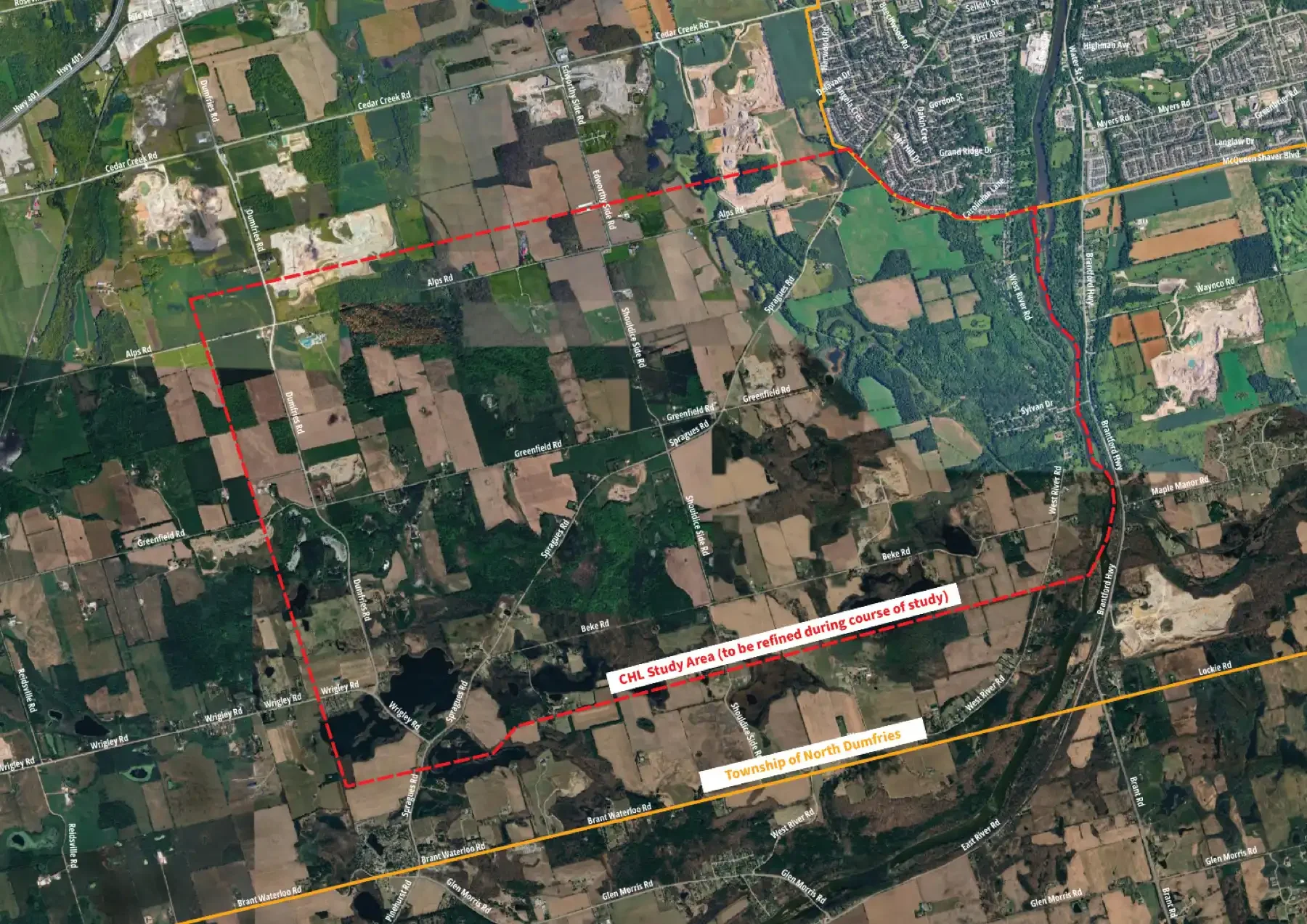
The Spragues Road District Study Area includes Spragues Road and the surrounding rural lands — including agricultural properties, woodlots and waterbodies — extending from the north side of Alps Road to the south side of Beke Road, between the Grand River and the west side of Dumfries and Wrigley roads. All or part of the Dryden Tract, Sudden Regional Forest, Drynan Regional Forest, Wrigley’s Lake, Deans Lake, Elliots Lake, Millers Lake and Bannister Lake are located within the Study Area boundaries. The area reflects overlapping geomorphological, Indigenous, treaty, land division, settlement, agricultural and transportation histories, as well as subsequent changes in land use and relationships between developed, agricultural and environmental conservation areas. Council has directed staff to collaborate with heritage experts to undertake a technical study of the area and, as an initial step, to ground-truth and refine the proposed Study Area boundaries based on preliminary research and field investigation.
What is a Cultural Heritage Landscape?
For this study, the Provincial Planning Statement, 2024 definition of cultural heritage landscape will be used as the working definition.
Per the 2024 PPS:
“Cultural heritage landscape” means a defined geographical area that may have been modified by human activity and is identified as having cultural heritage value or interest by a community, including an Indigenous community. The area may include features such as buildings, structures, spaces, views, archaeological sites or natural elements that are valued together for their interrelationship, meaning or association.
Study Approach
The study will examine the Spragues Road District as a cultural heritage landscape.
This involves considering the relationships between environmental systems, agricultural and other land-use patterns, settlement history, circulation routes, views, built features, Indigenous presence and knowledge, community memory, and ongoing relationships to place. Rather than evaluating individual features in isolation, the study will seek to understand the area as a living and evolving landscape shaped by layered relationships between people and place over time.
How the Study Will Be Conducted
The study will proceed through three broad stages: understanding the landscape, evaluating significance, and developing recommendations.
-
Understanding the Landscape
Research, fieldwork, mapping, and community engagement will help build an understanding of the area’s history, evolution, landscape patterns, and community significance. Engagement with Mississaugas of the Credit First Nation (MCFN) and the Six Nations of the Grand River - Elected Council (SNGR-EC), as well as other Indigenous stakeholders, will also help inform the study’s understanding of the landscape, including its history, cultural significance, and ongoing relationships to place.
Mapping will be used throughout the study to identify landscape patterns, understand relationships between features, help define landscape boundaries, and communicate findings.
-
Evaluating Significance
Information gathered through research, field investigation, mapping, and engagement will be assessed to determine whether the Study Area demonstrates cultural heritage value or interest and whether identification as a Cultural Heritage Landscape is appropriate.
The CHL Study will use the Region of Waterloo’s Implementation Guideline for Cultural Heritage Landscape Conservation as a starting point for evaluating the Study Area. The project team will review the Guideline’s criteria for their applicability to the Spragues Road District, identify any additional considerations that may be appropriate, and use the resulting evaluation framework to assess the area.
-
Developing Recommendations
If the Study Area is found to demonstrate cultural heritage value or interest, the study will identify opportunities for conservation, stewardship, and planning policy implementation, including recommendations to inform the Township’s Official Plan.